| Chapter 11. Geometry input | ||
|---|---|---|
 | Part III. HyperAdmin |  |
| Chapter 11. Geometry input | ||
|---|---|---|
| | Part III. HyperAdmin | |
Table of Contents
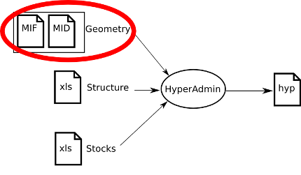
This section describes the expected geometry input for Standard HyperAdmin.
![[Important]](../images/important.gif) | |
The maps are computed using the geometric information from the lowest level of territorial units, then aggregating this information to build the upper levels. So, the user must provide data without any hole, and territorial units at lowest level must be contiguous. |
Expected geographical information must be provided by the user in the MIF/MID format (MapInfo format). For more information on this software and its format, please consult http://www.pbmapinfo.eu/ (last visit: 13rd may 2010).
| |  | |
| Chapter 10. Standard HyperAdmin Overview |  | 11.1. The MID file |