| Chapter 10. Standard HyperAdmin Overview | ||
|---|---|---|
 | Part III. HyperAdmin |  |
| Chapter 10. Standard HyperAdmin Overview | ||
|---|---|---|
| | Part III. HyperAdmin | |
In order to perform Multiscalar Territorial Analysis with Standard HyperAtlas, the datasets provided by geographers are serialized in a convenient format
into a binary file named with the .hyp extension. As a convention, a Standard HyperAtlas dataset input file is called an hyp file (example: demography.hyp).
Standard HyperAdmin is the tool to generate hyp files from your a set of input well-formed files. The steps to generate an hyp file and the workflow between Standard HyperAdmin and Standard HyperAtlas is summarized in the Figure 10.1.
Figure 10.1. Standard HyperCarte Workflow
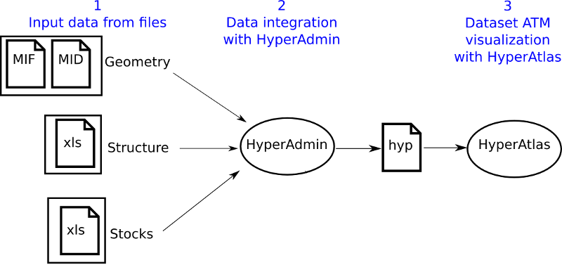
Standard HyperAdmin and Standard HyperAtlas data flow.
To sum up, the main expected input files are:
the geometry of the dataset, in MapInfo MIF/MID formats:
the MIF file
the MID file
the structure of the dataset, as an xls (Excel/OpenOffice) file
the stocks of the dataset, as an xls (Excel/OpenOffice) file
As shown on Figure 10.1, creating a dataset hyp file consists in:
preparing your dataset geometry as a MIF/MID files pair (MapInfo format);
preparing your dataset structure as a speadsheet structure.xls file;
optionally, preparing a distance-time matrix as an xlsfile for custom contiguities;
preparing your dataset stocks as a spreadsheet (Excel/OpenOffice) data.xls file;
generating the dataset hyp file with Standard HyperAdmin.
Following chapters describe each above step for integrating your data into an hyp file.
| |  | |
| Part III. HyperAdmin |  | Chapter 11. Geometry input |