| Chapter 2. HyperAdmin Overview | ||
|---|---|---|
 |  | |
| Chapter 2. HyperAdmin Overview | ||
|---|---|---|
| | | |
In order to perform Multiscalar Territorial Analysis with HyperAtlas, the datasets provided by geographers are serialized in a convenient format
into a binary file named with the .hyp extension. As a convention, a HyperAtlas dataset input file is called an hyp file (example: demography.hyp).
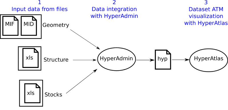
HyperAdmin is the tool to generate hyp files from your a set of input well-formed files. The steps to generate an hyp file and the workflow between HyperAdmin and HyperAtlas is summarized in the Figure 2.1.
As shown on Figure 2.1, creating a dataset hyp file consists in:
preparing your dataset geometry as a MIF/MID files pair (MapInfo format);
preparing your dataset structure as a speadsheet structure.xls file;
optionally, preparing a distance-time matrix as an xlsfile for custom contiguities;
preparing your dataset stocks as a spreadsheet (Excel/OpenOffice) data.xls file;
generating the dataset hyp file with HyperAdmin.
Following chapters describe each above step for integrating your data into an hyp file.
| | | |
| Chapter 1. Introduction: HyperCarte Research Group |  | Chapter 3. Geometry input |