

hyperadminimal est un prototype destiné à construire des jeux de données .hyp compatibles et optimisés pour HyperAtlas v2. hyperadminimal génère des .hyp à partir d'une mise à jour "v2" des fichiers "data/stocks" au format xls. La mise à jour v2 de ces fichiers stocks consiste en la possibilité de référencer un indicateur à plusieurs dates (exemple : PIB en 2000, 2002, etc).
Disponible en version application de bureau, hyperadminimal se distingue de hyperadmin par une interface graphique minimale (pas de rendu cartographique à la HyperAtlas) et ne nécessite plus de base de données PostgreSQL PostGIS pour le calcul des contiguïtés.
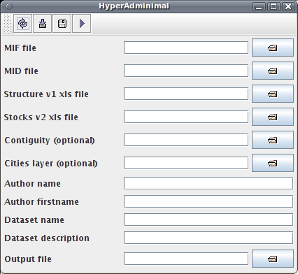
hyperadminimal invite l'utilisateur à construire un .hyp à partir d'un formulaire (voir figure ci-dessous) pour indiquer les fichiers nécessaires :
Téléchargement du prototype version "forge imag hypercarte svn revision 668" : hyperadminimal.jar
Manuel utilisateur (en anglais) du prototype hyperadminimal pour la construction des jeux de données .hyp v2 :
Réalisés dans le cadre du projet ESPON HyperAtlas Update (2011), trouvez ci-dessous quelques templates de fichiers nécessaires pour la construction d'un .hyp avec hyperadminimal.
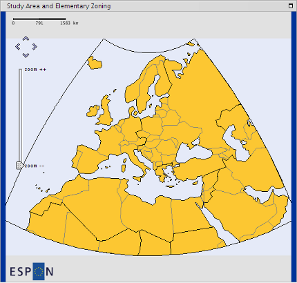
This template considers the WUTS nomenclature at levels 3-4-5 on the EUROMED area. The following screenshot shows the study area and the elementary zoning of the EUROMED geometry template at WUTS 5 level.
Content of the template archive hyp_template_euromed_wuts-3-4-5.zip
hyp_template_euromed_wuts-3-4-5
  |- euromed_data.xls
  |- description.txt
  |- euromed.mif
  |- euromed.mid
  |- euromed_structure.xls
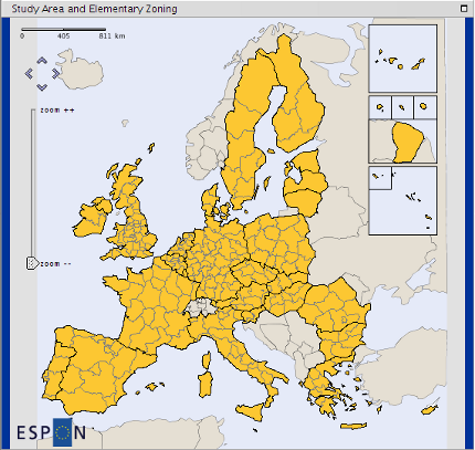
This template considers 27 European states, the delineation is based on the NUTS 2006 nomenclature, at NUTS 2 lowest mesh level. The following screenshot shows the study area and the elementary zoning of the EU 27 NUTS 2 geometry template at NUTS 2 level.
Content of the template archive hyp_template_eu27_nuts2006-0-1-2.zip:
hyp_template_eu27_nuts2006-0-1-2
  |- eu27nuts2_structure.xls
  |- cities_europe.csv
  |- description.txt
  |- eu27nuts2.mif
  |- eu27nuts2_data.xls
  |- eu27nuts2.mid
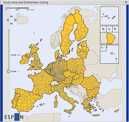
This template considers 27 European states, the delineation is based on the NUTS 2006 nomenclature, at NUTS 3 lowest mesh level. The following screenshot shows the study area and the elementary zoning of the EU 27 NUTS 3 geometry template at NUTS 3 level.
Content of the template archive hyp_template_eu27_nuts2006-0-1-2-3.zip
hyp_template_eu27_nuts2006-0-1-2-3
  |- eu27nuts3.mif
  |- cities_europe.csv
  |- eu27nuts3_data.xls
  |- description.txt
  |- eu27nuts3.mid
  |- eu27nuts3_structure.xls
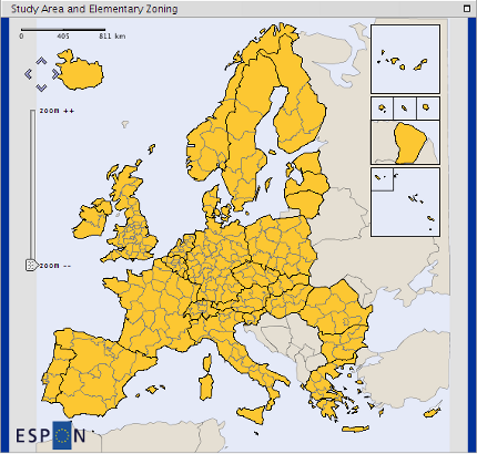
This template considers 31 countries of the ESPON Area: EU 27 + 4 EFTA (European Free Trade Association) countries (Norway, Switzerland, Liechtenstein and Iceland), the lowest mesh level is NUTS 2. The following screenshot shows the study area and the elementary zoning of the EU 31 NUTS 2 geometry template at NUTS 2 level.
Content of the template archive hyp_template_eu31_nuts2006-0-1-2.zip
hyp_template_eu31_nuts2006-0-1-2
  |- eu31nuts2_data.xls
  |- cities_europe.csv
  |- eu31nuts2.mif
  |- eu31nuts2_structure.xls
  |- description.txt
  |- eu31nuts2.mid
$Revision: 762 $ on $Date: 2014-11-05 16:10:56 +0100 (Wed, 05 Nov 2014) $ by $Author: blerubrus $